- Airspace
- Airspace Classes
- Cloud Clearance
- Summary
- NOTAMS
- Flying Sites Affected by Airspace
- Northern Ireland
- Airspace
- Airspace Classes
- Cloud Clearance
- Summary
- NOTAMS
- Flying Sites Affected by Airspace
- Northern Ireland
Airspace
All pilots are strongly advised to own an up to date Sectional Chart showing the extent and limits of controlled airspace in Ireland. VFR sectional charts are available from the Ordenence Survey of Ireland shop in both 1:250,000 and 1:500,000 scale. The 1:250,000 charts are more detailed and come in four charts covering all of Ireland. The 1:500,000 chart covers all of Ireland on a single chart, and is sufficiently detailed for IHPA pilots to safely plan cross country flights.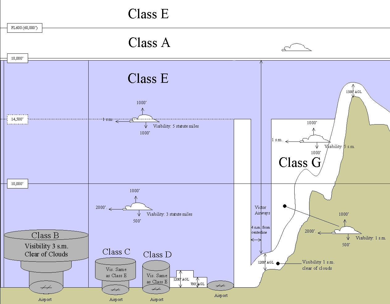
Airspace Classes
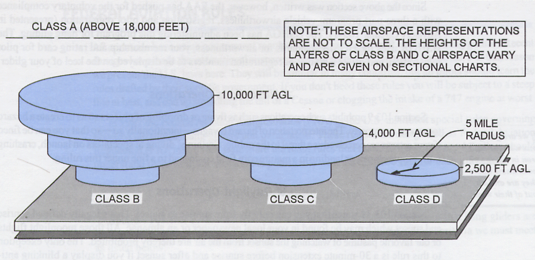
- Class A (Above everything else) extends from 18,000 feet (5,500m) Above Mean Sea Level (AMSL) to 60,000 feet, and is not represented on sectional charts.
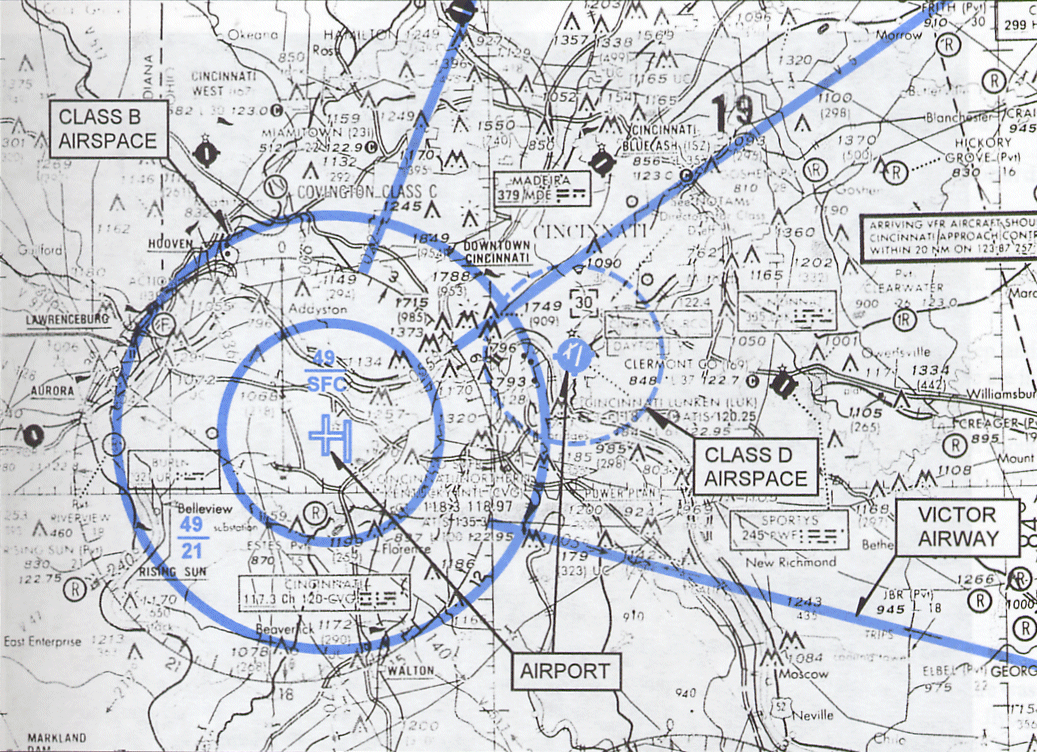
- Class B (Busy airport) extends from ground level to 10,000 feet Above Ground Level (AGL) and surrounds large busy airports. Class B airspace looks like an upside-down wedding cake and is represented on sectional charts as a thick blue line that describes a number of concentric vertical cylinders of different radius and vertical extent. There is no Class B airspace in Ireland.
- Class C (City airport) surrounds less busy city airports (Dublin, Shannon, Cork & Belfast.) Class C airspace is similar to class B, but lower; generally a cylinder around the airport that is 5 miles in diameter extending from the surface to 1,200 feet AGL, and expanding to a cylinder 10 miles in diameter from that point to 4,000 feet AGL. Class C airspace is represented on sectional charts as a thick magenta (purple) line. We may fly in Class C airspace with specific authorisation from Air Traffic Control (ATC) as long as we operate under Visual Flight Rules (VFR) and remain 500 feet below, and 2000 feet horozontal distance from clouds and as long as there is at least three miles visibility. Some of our flying sites (Killiney and Kinsale) are inside class C airspace. [NB: Class C cylinders not correct here! SFC-5000' and 5000'-... verify from latest VFR maps.]
- Class D (Dashed line) is shown on airspace sectional charts as a blue dashed circle around a small airport or aerodrome. The circle describes a vertical cylinder with a radius of 5 miles (8km) extending from the ground up to 2,500 feet Above Ground Level (AGL)
- Class E (Everything else) is controlled airspace starting at 14,500 feet AMSL and extending up to the next overlying airspace (A, B, C or D) with the following exceptions:
- Class E floor is 1500' AGL if surface is above 14,500' AMSL - Not relevant in Ireland.
- Class E floor is 1200' AGL (or more) if inside shaded blue line.
- Class E floor is 700' AGL if inside shaded magenta (purple) line.
- Broken blue lines differentiate Class E floors when floor is above 700' AGL.
- We may fly in Class E airspace.
- Class F Currently not defined.
- Class G (Near the Ground) is uncontrolled airspace extending from the ground up to the next overlying airspace (usually E.) We may fly in Class G airspace with the least requirements - see Cloud Clearance, below.
- Victor Airways are represented on sectional charts as long straight blue lines, these are designated flight paths for commercial air traffic crossing the country or approaching large airports. Victor Airways are generally eight miles wide.
- Prohibited Areas are areas of national security or national welfare (give examples - if any) and may not be entered under any cirumstances.
- Restricted Areas are military training areas and may only be entered when they are not in active use. These areas usually spend more time being inactive than active. If the area is not in active use then you are permitted to fly over them under VFR. You must check with the nearest ATC to find out whether or not a Restricted Area is in active use or not. There are a number of Restricted Areas in Ireland.
- AMSL - Above Mean Sea Level.
- Flight Level (FL) on aeronautical charts is an expression of Altitude in hundreds of feet. Thus FL25 is 2,500 feet, FL75 is 7,500 feet and FL350 is 35,000 feet. Controlled airspace around the larger airports of Dublin,Shannon and Cork are defined by at least three concentric circles: the outer, largest circle is usually defined as Class C FL245/3500FT, which tells you that within this circle controlled airspace extends from 24,500 feet down to 3,500 feet AMSL. The next, smaller circle is usually defined as Class C FL245/2500FT extends from the same upper altitude of 24,500 feet and comes down closer to the ground to 2,500 feet. The centre circle is usually defined as Class C FL245/SFC and extends all the way to the surface (SFC.)
Cloud Clearance
Cloud Clearance below 10,000 feet
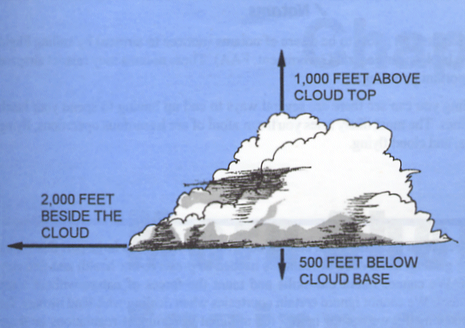
Hang Gliders and Paragliders must maintain visual reference with the ground at all times. It is illegal (and dangerous!) to fly inside cloud, as is getting to cloud base. This graphic shows the minimum distances you need to maintain from cloud to comply with Visual Flight Rules (VFR).
Summary
Airspace we can NOT enter:- Over any congested area of a city, town, or settlement (FAR 103.15)
- Over any open air assembly of persons (FAR 103.15)
Airspace we can enter only with prior authorization from the controlling authority:
- Class A, B, C, D controlled airspace (FAR 103.17)
- Lateral boundaries of Class E airspace designated for an airport (FAR 103.17)
- Prohibited or Restricted Areas (FAR 103.19)
- Areas designated in a Notice to Airmen (NOTAM) (FAR 103.20)
Airspace we CAN enter without prior authorization from any controlling authority:
- Airspace not defined above (Class G and most of Class E)
Flying Sites Affected by Airspace
The three main airports (Dublin, Shannon and Cork) have extensive Class C controlled areas around them. The smaller airports (Waterford, Knock, Farranfore, Galway, Sligo and Donegal) have a 10 nautical mile radius cylinder of airspace controlled by local ATC. These smaller, regional airports also have additional stubs, generally 10 nautical miles long and wide, along extended runway centrelines, extending from 2500 feet AMSL upwards. These stubs are controlled by Shannon ATC. You can safely fly below these stubs (i.e. below 2500 feet).
Flying Sites In, Under or Near Controlled Airspace in Ireland
The following flying sites are located either inside, underneath or near controlled air space and require either specific permission or knowledge before they may be flown. Please be aware that by flying these sites without permission or by violating the restrictions laid down by Air Traffic Control you are endangering not only your own life but also the lives of others. You also run the risk of having a good flying site closed permenantly and earning the emnity of every other pilot in the country. The rules and restrictions are there for your safety and the safety of others - obey them.
All hang gliding and paragliding flights must be conducted in accordance with Normal Visual Flight Rules unless express permission is granted by Air Traffic Control, in which case the flight is governed by Special Visual Flight Rules.
- Normal VFR - This is a daylight flight with three miles visibility and 1000' clearance from clouds (verticle and horozontal clearance.)
- Special VFR - This is a clearance, from ATC, permitting a VFR flight to operate in controlled airspace with minimums of 1 mile visibility, and "clear of clouds."
- VFR ends at sundown, when the sun touches the horizon. This is a different time each day, which ATC will advise you of.
Killiney (Co. Dublin) - This site is inside Class C airspace for Dublin airport and may only be flown with the expressed permission from Dublin Air Traffic Control. Permission is always subject to restrictions - you must not fly above 700 feet above sea level and you must remain within one mile of the obilisk on top of the hill. Note, also, that Killiney is a hazerdous site and has a 50-hour restriction on it. Pilots MUST have a minimum of 50 hours air time experience before attempting to fly there. Following a safety review in 2007 a new protocol has been agreed with Dublin ATC. Permission to fly at Killiney is based on the following ATC stipulated conditions:
- Pilots are required to be current members of the IHPA.
- Pilots are required to hold a minimum pilot rating of Para Pro 3 (or Safe Pro 3) or above.
- Pilots are required to have logged in excess of 50 hours of air time experience.
- Pilots are required to hold a suitable and valid insurance policy.
- Pilots are required to call Dublin ATC for permission to fly (and to notify ATC after flying activities have ceased for the day.)
Pilots wishing to fly at Killiney MUST contact Dublin ATC on 01 8144601 and ask for the Data Assistant. A typical call will go as follows:
Pilot: "Hello, may I speak to the Data Assistant please?"
Dublin ATC: "This is the Data Assistant speaking, how can I help you?"
Pilot: "My name is Joe Bloggs. I am a Paraglider / Hang Glider pilot seeking permission to fly at Killiney Hill."
Dublin ATC: "Ok, when do you wish to commence flying operations at Killiney?"
Pilot: "From now (give the current time) until the end of VFR (Visual Flight Rules) and I would be grateful if you would advise all powered aircraft to avoid this area please."
Dublin ATC: "One moment please while I check with the Duty Controller."
At this point your call may be passed on to the Duty Controller and you should repeat your request again to him.
Dublin ATC: "Ok, you are cleared to fly at Killiney from now until the end of VFR which is at 18:30 (or whatever time VFR ends at.) Your flight operations are restricted to under 700 feet AMSL (Above Mean Sea Level) and to within one mile radius of Killiney Hill. Please call back when flight operations have ceased for the day."
Pilot: "Ok, just to confirm: I am cleared to fly at Killiney Hill from now (give the time) until the end of VFR at 18:30 (or whatever time you were told.) Flight operations are to be restricted to under 700 feet AMSL and to within one mile radius of Killiney Hill. Correct?"
Dublin ATC: "That's correct. Thanks for calling." Click, burrrr....
Remember, your call is being recorded so keep your conversation polite, courteous and professional - stick to the script!
If helicopters or other small aircraft fly close in front of Killiney Hill while you are flying, please do not call Dublin ATC to complain. Note down the time and date of the incident and the type of aircraft infringing your agreed airspace and call or email the IHPA Training & Flight Safety Officer who will take appropriate action. Remember, you are receiving PERMISSION to fly at Killiney Hill, not a cast iron guarantee that you have the air all to yourself!
At the end of a day's flying, normal practice is that the last pilot out of the air MUST call Dublin ATC back to advise them that flight operations have ceased for the day. Again, a typical call will go as follows:
Pilot: "Hello, may I speak to the Data Assistant please?"
Dublin ATC: "This is the Data Assistant speaking, how can I help you?"
Pilot: "My name is Joe Bloggs. I am calling to advise you that Paragliding / Hang Gliding flight operations at Killiney Hill have ceased for the day."
Dublin ATC: "Paragliding / Hang Gliding operations have ceased for the day at Killiney Hill. Ok, thanks for your call." Click, burrr...
Gormanston Dunes (Co. Dublin) - The coastal sand dunes adjacent to the Gormanston Military Camp are inside the EID1 Danger Area. The Irish Defense Forces regularly conduct live fire artillery, rifle and weapons exercises from this location (and out to sea) throughout the year. The Department of Defense has asked us not to fly either paragliders or hang gliders along this stretch of the coast as they consider it inherently dangerous. The irregular periods when the EID1 airspace restriction is active are published by NOTAM (Notices to Airmen.) Please do not fly or infringe on this Danger Area when it is active. Pilots can review the active NOTAMs for Ireland here: http://notaminfo.com/irelandmap
Bray Head (Co. Wicklow) - Bray Head lies below the Dublin Control Traffic Area, which extends from 2500 feet upwards. You are unlikely to reach 2500 feet at Bray so there is no danger of infringing on that.
Lough Bray (Co. Wicklow) - Lough Bray lies just south of the Dublin Control Zone. Do not go over the back of Lough Bray towards Tallaght because you will first enter Dublin Control Zone, and then cross into Baldonnel Restricted airspace. Heading west towards the transmitter on Kippure is fine. Lough Bray is part of the Wicklow Mountains National Park. The WMNP Authority requires all sporting activities taking place within the park to be approved and subject to conditions covered in their Permit. Click >here< to view the WMNP Permit.
Lacken (Co. Wicklow) - This site is in airspace controlled by Casement Military Aerodrome at Baldonnel. Check airspace class and restrictions. Call Casement ATC on 01 403 7514 if you plan to fly there mid-week and alert them to your activities. There have been a number of instances where low-flying helicopters have come close to PGs/HGs in the air.
Arra, Keeper Hill and Silvermines (Co. Tiperrary) - Keeper Hill and most of the Silvermines are below the Shannon Control Area. Pilots should call Shannon ATC on 061 770700 and ask to speak to the Supervisor. The main directions on Arra are South West to West. It is possible to fly it on a Northwesterly but you need a stiffer breeze. Take off is about 1500 and when you ring ATC, they normally give you 1000ft above the hill. On rare occasions they can give you more height than this but usually only about another 500 ft. Keeper Hill is slightly further away from Shannon than Arra. The Hill is 2200 ft and normally one can get to 3500 AMSL clearance from ATC. Going cross country from Keeper is taking a fairly big risk. There is a lot of air traffic passing over (below cloudbase regularly) and as a result, we haven't flown there that often in recent years. Best directions for flying Keeper is NE right around to SW. Bear in mind the NE take off involves a nerve racking take off over a huge gully. (nearly a cliff launch).
Blackstair Mountains (Co. Wexford/Carlow) - Pilots flying cross country off the southern end of the Blackstair Mts. should be aware that there is controlled air space around Waterford City and should plan their flight path accordingly.
Comeragh Mts. (Co. Waterford) - While this site is not inside any air traffic control zone it is frequently used by the Waterford Search & Rescue helicopter for training exercises. Pilots intending to fly the Comeragh Mts. should call the Search & Rescue base and advise them of your activities before and after you fly. You should specifically explain the danger posed to hang gliders and paragliders from the turbulence caused by the helicopter and request that they do not fly into the area unless there is a genuine emergency. Pilots should also call to advise them when HG/PG activities have ceased for the day. Waterford Search & Rescue: 051 875265.
Kinsale (Co. Cork) - All flying sites around Kinsale are inside Class C airspace controlled by Cork ATC. Pilots wishing to fly in or through this area must call Cork Tower on (021) 4329623 and request permission to fly. The format for requesting clearance is: "Hello Cork tower, this is a paraglider pilot on the ground at the Old Head of Kinsale. I request clearance for 2 hours paragliding on the cliffs south and west of the Old Head. Maximum altitude 500ft QNH. I will call you when finished." When finished call the tower again and say " the paragliders are on the ground at (say time) at Kinsale." They are very nice people and are now used to us calling them. They want us to let them know what we are doing and always thank us for calling in. Please read Tony Taylor's excellent site Guide here.
Slieve Mish (Co. Kerry) - Part of Slieve Mish is inside the Farranfore CTA (Controlled Traffic Area.) Farranfore airport have made it clear that they will not tolerate any free-flying activity in their airspace unless the pilots are equipped with airband radios and are in direct communication with the Farranfore tower at all times. Airband radios require the operator to have an RT licence. So, for the forseeable future, pilots wishing to fly the length of the Dingle peninsula must not enter Farranfore airspace at any time. Please check your airspace maps before flying in this part of the country. The IHPA will continue to endevour to have this policy changed so that it is treated similarly to other flying sites inside air traffic control zones.
Rossbehey (Co. Kerry) - This site lies just outside the Farranfore CTA and must be flown with due attention to the extent of Farranfore controlled airspace. Please check your airspace maps before flying this site.
Truskmore & Benbulbin (Co. Sligo) - Truskmore is on the edge of the Sligo Control Zone. If you fly west or south from Truskmore you are in controlled airspace. Contact Sligo ATC on 071 916 8461 beforehand if you want to fly the hills west of Truskmore, including Ben Bulben. Truskmore and Benbulbin are frequently used by the Sligo Airport based Irish Coast Guard Sikorsky S92 helicopters for SAR training. Pilots MUST contact Sligo ATC prior to flying at any of these locations, including flights in close proximity to Truskmore which are planned to take place outside the Control Zone.
Knocknarae (Co. Sligo) - This site is right beside (overlooking) Sligo Regional Airport and inside Class C airspace. Permission MUST be obtained from Sligo ATC before flying commences, and XC flights are strictly prohibited. Contact Sligo ATC on 071 916 8461. Local pilots have worked hard to establish a good relationship with the airport, so please don't jeopardise their work by flying without permission!
Dublin ATC (EIDW) 01 8144601 - Call before you fly at Killiney.
Casement ATC (EIME) 01 403 7514 - Call before you fly at Lacken.
Sligo Airport (EISG) 071 916 8461 - Call before you fly at Knocknarae, Truskmore or Benbulbin
Donegal Airport (EIDL) 074 9548284
Galway Airport (EICM) 091 755569
Shannon Airport (EINN) 061 712000
Cork Airport Tower (EICK) 021 4329623 - Call before you fly at Kinsale - Please read the site guide before you fly there.
Farranfore Airport (EIKY) 066 9764644 - Kerry Regional Airport
Knock Airport (EIKN) 094 936 8100
Waterford S&R (EIWF) 051 875265 - Call before you fly the Comeragh Mts.
North of Ireland
Aldergrove ATC - 028 9448 4281 - Aldergrove ATC have requested that we use this number when calling to activate designated areas under the LOA.
Belfast City ATC - 028 9045 4871
Eglinton ATC - 028 7181 1099
Northern Ireland
Northern Ireland Flying Sites Restrictions
Hello All,
Please read the email below from Mark Piggott/ UHPC concerning the recent change in airspace around Belfast and the Letter Of Agreement (LOA) that has been agreed between the UHPC and Aldergrove ATC to facilitate flying in the affected areas. Please read the email below carefully and understand what it means for you if you are planning on flying in these areas.
The LOA makes specific reference to members of the UHPC and Algergrove ATC so non UHPC members are not covered by it, effectively denying access for non members to the 5 designated areas within Class D airspace described. So if you are planning to fly in these areas and there is the possibility you will infringe Class D airspace you will need a member of the UHPC to activate the LOA. I'm sure all of you who fly north of the border will have contacts within the UHPC and my advice is to get in touch to discuss.
It is essential that you DO NOT INFRINGE CLASS D airspace unless you have prior permission.
This is a legal requirement and applies to us all.
Note: This is a similar arrangement to the LOA between the IHPA and Dublin ATC allowing us to fly at Killiney which is within the Dublin CTR. This has been in place for many years and for the most part works very well. However from time to time, either through lack of knowledge or lack of consideration, a pilot will fly at Killiney without first activating the LOA. This is a serious breach of airlaw and could easily result in the LOA being retracted and the site being closed to us all. Don't be fooled that you won't be seen - Killiney is visible from Dublin control tower and ATC receive constant updates from the GA and commercial airline traffic so it is highly likely they know when we are flying there.
Many thanks, and safe flying,
David May
IHPA Secretary
=======================================================
Email from Mark Piggott of UHPC
=======================================================
Please read this very carefully.
On Thursday 26-May-2016 all Class E airspace in the Belfast TMA will be reclassified to Class D.
Paragliders and hang gliders are permitted to fly in Class E without contacting Air Traffic Control (ATC) but this is not the case for Class D.
Class D is effectively closed to us.
This reclassification affects the following sites:-
|
Site |
Soarable Wind Direction |
Hill Height |
Class D (formerly Class E) |
|
1.1 Knockagh Monument |
S-SE |
865 |
2000 |
|
1.2 Agnew's Hill |
E-SE |
1555 |
2000 |
|
1.3 Shane's Hill |
SE |
1555 |
2000 |
|
1.4 Big Collin |
S-SE |
1158 |
2000 |
|
1.5 Divis & Cavehill |
E-SE |
1698 (mast) |
Class D |
|
1.6 Slieve Croob |
N-E |
1752 |
3500 |
|
1.7Slieve Donard |
All |
2789 |
3500 |
The UHPC, BHPA and UGC all strenuously opposed the airspace change and submitted independent but coordinated objections within the consultation period.
Although unable to prevent the airspace change from going ahead, the CAA did make it a condition that Aldergrove ATC must agree and sign a Letter of Agreement (LOA) with the UHPC before implementation.
After a number of meetings and negotiations the LOA was signed yesterday. It defines five “designated areas” or boxes within Class D airspace that UHPC members can activate for our use.
1. Big Collin/Agnews
2. Knockagh
3. Slieve Croob
4. Slieve Donard
5. Divis/Cave Hill (not yet available to fly as negotiations with National Trust continue)
It is possible to soar all these sites (except Divis) without the need to contact ATC provided Class D airspace is not infringed.
This is particularly an issue at Agnew's where Class D starts only 445 feet above the top of the hill - easily reached in good soaring conditions.
If XC flights or high soaring flights are possible then it is essential to contact ATC to activate the 'designated areas' and obtain clearance to fly.
So if you wish to fly in Class D airspace you MUST:
1. Read the Letter of Agreement (attached) and ensure you fully understand it. It is the law.
2. Ensure you have a GPS or properly set altimeter.
3. Ensure you have a working radio tuned to the club frequency 144.725MHz
4. Follow the "UHPC Procedure" defined in section 6.1 precisely.
This is an extract from the LOA, however before contacting ATC you must read and fully understand the LOA.
The LOA contains the box boundaries and illustrative maps.
6.1 UHPC Procedure
1. All UHPC pilots must be briefed before activating this LOA.
2. A UHPC pilot will contact ATC at Aldergrove at least 15 mins prior to a planned flight to agree a time window and maximum permitted altitude for the required flying area.
3. When a site is activated, the pilot initiating the activation will leave his name and contact number with ATC in case of emergency.
4. On receiving an emergency call from ATC, the pilot will ensure that the call is responded to within 15 mins. If required, this pilot must have a method of ensuring that the area is vacated and shall advise Belfast/Aldergrove ATC when this is complete.
5. Other pilots must confirm the vertical extent and time window before launch by contacting ATC or another informed pilot.
6. All times agreed between ATC and the UHPC will be ‘local’ time.
7. UHPC pilots will ensure that they are flying with a means of determining altitude (amsl) whether by GPS or barometric altimeter set to QNH. Such devices will have a tolerance of +/- 100ft.
8. Pilots will ensure that they remain within the defined lateral notified areas of each designated site where bounded by Class D Airspace.
9. Pilots will ensure that they meet the VFR flight minima as published for Class D Airspace.
10. A UHPC pilot will notify ATC when flying has ceased earlier than the agreed expiry time.
11. These LOAs refer only to segregated flying activity within Class D Airspace. ATC has no control or authority over other IFR/VFR flights which may be operating within Class G Airspace beneath the designated areas.
12. Pilots must be aware that other VFR flights may transit the Designated Areas during the times of activation.
The "method of ensuring the area is vacated" is by FM radio on the club frequency 144.725MHz.
Regards,
Mark Piggott
Air Liaison Officer - UHPC

